Some of the most stunning sights on the planet were created by nature. Those sights tend to inspire a greater amount of awe because they are a product of the environment we live in every day. In 2008, an organization known as Seven Natural Wonders was established in an effort to protect these precious places. The overall mission of the Seven Natural Wonders project was to promote global understanding of these wonders, educate people on threats to the existence of the wonders and help people practice the conservation of these inspiring natural sights.
Although there are other organizations who have made an effort to establish other lists of 7 wonders, the list compiled by Seven Natural Wonders was published by CNN in 1997 and is the most commonly accepted compilation of wonders. The impressive wonders that were selected for the final list were chosen by highly reputable experts in global exploration, conservation and nature based on traditional and statistical significance, level of uniqueness and level of natural splendor.
AURORA BOREALIS
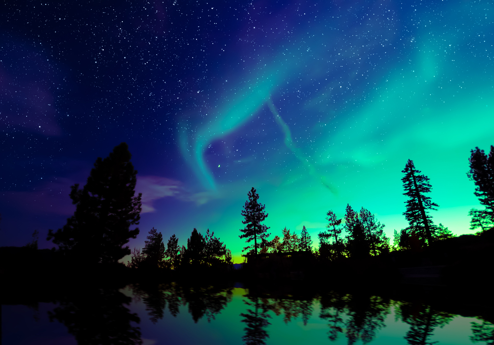
Also commonly known as auroras, or the Northern Lights, they can be seen in both polar regions of the planet but tend to be more stunningly visual in the Northern Hemisphere. The best place to witness this amazing phenomena is from higher altitudes in the northwestern regions of Canada, such as Yukon and Nunavit, along with Alaska.
HISTORY
There have been several mentions of the northern lights dating all the way back to China in 2600 B.C. but the term Aurora Borealis is credited to Galileo Galilei in 1619 A.D. He named the lights after the Roman goddess of dawn, Aurora, and the Roman god of the north wind, Boreas. The southern lights are referred to as Aurora Australis, however, the inhospitable nature of the southernmost pole makes these lights much more difficult to view and enjoy than their northern counterparts.
WHAT CAUSES IT?
The lights of the Aurora Borealis are a direct result of gaseous particles present in the Earth’s atmosphere colliding with highly charged particles that are released from the sun. Depending on the different types of gases, combined with specific altitude of those gases, substantially different colors can be produced. Although the most common color reported is a green, it is possible to view reds, yellows, pinks and blues.
FACTS
- Other planets, including Jupiter and Saturn, experience their own versions of this phenomenon.
- There have been reports of Northern light sightings as far south as Cuba.
- The astronauts on the International Space Station view the lights from the side because they are positioned at the same altitude.
THE GRAND CANYON
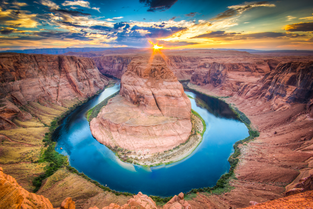
This majestic canyon is located in the northwest corner of the state of Arizona and was carved out by the Colorado River. Nearly 5 million people visit this wonder every year with the majority of them viewing from the highly accessible South Rim.
HISTORY
This amazing feat of nature measures over 270 miles long, 18 miles wide and up to a mile deep. Although there is some controversy concerning the true age of the canyon, scientists now believe there are parts dating back 16-17 million years. The area has been highly resourceful for humans throughout its existence, with artifacts pointing to human presence dating back close to 12,000 years.
WHAT CAUSED IT?
Another subject of debate among scientists are the exact processes that led to the formation of this impressive gorge. One of the most widely accepted beliefs about the formation of the Grand Canyon is that the flow of the Colorado River, over the course of millions of years, eroded the canyon to what it is today. The constant movement of water, combined with heat, uplift and wind exposed this breathtaking canyon.
FACTS
- The Grand Canyon is home to nearly 70 different species of mammals, 250 species of birds, 25 types of reptiles and 5 species of amphibians
- The area surrounding the Grand Canyon was made a national park in 1919 and covers 1,900 square miles
- The area is populated by 5 different Native American tribes: The Hopi, Navajo, Havasupai, Paiute and Hualapai
- Bus tour companies offering Grand Canyon Tours bring in millions of visitors each year
- In 2017, over 6.2 million people visited Grand Canyon National Park
VICTORIA FALLS
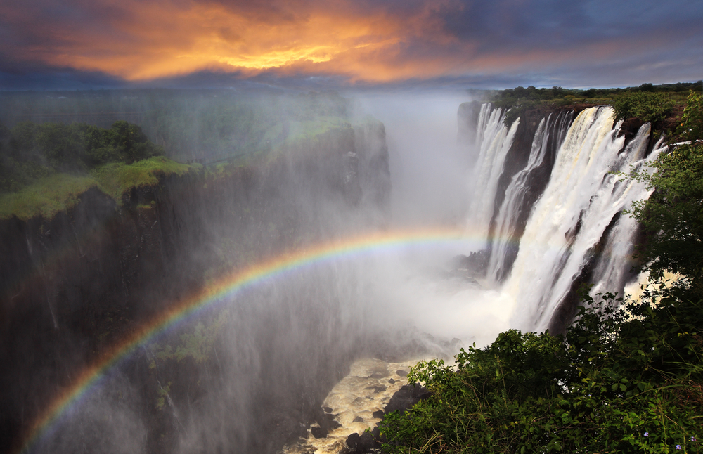
As one of the most recognized waterfalls in the world, and a UNESCO World Heritage Site, Victoria Falls also has the distinction of being the largest curtain of falling water in the world. Located on the national border of Zambia and Zimbabwe, the falls are a product of the Zambezi River plunging up to 354 feet down into gorges of basalt. Thousands of people visit the area each year for the opportunity to tour Victoria Falls and the surrounding area.
HISTORY
Archaeologists have found stone artifacts in the area directly surrounding the falls traced back around 2 million years ago, suggesting early human habitation in the area. Throughout the years, there have been several different tribes living in the area. The current name was given in 1855 by the first European to see the falls, David Livingstone, who named them after Queen Victoria. Traditionally, the falls have been known by locals as Mosi-oa-Tunya, or the “Smoke that Thunders.”
WHAT CAUSED IT?
The falls are only the current location of an ever evolving landscape on the Zambezi river. The plateau which the river flows across is made of basalt and weaker sandstone cracks. When the water erodes these cracks, gorges are eventually created. One of the most incredible aspects of Victoria Falls is the mist generated from the falling water that can be seen more than a dozen miles away, coupled with the famous and ever-present rainbow over the falls.
FACTS:
- During the low season, it is possible to swim in an area of low current, known as the Devil’s Pool, located just feet away from where the water flows over the edge.
- During the flood season, nearly 19 million cubic feet of water pass over the falls every minute.
- The falls create a rainforest-like atmosphere in the area, which is home to several endangered species.
THE GREAT BARRIER REEF
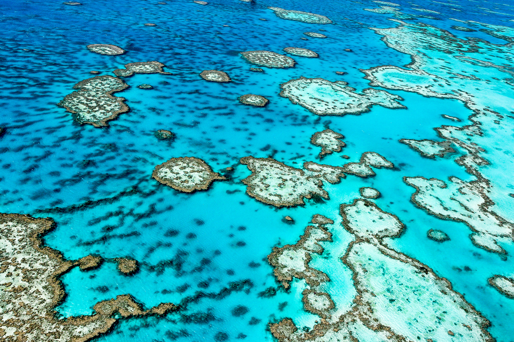
Larger than the Great Wall of China, and visible from space, the Great Barrier Reef is a breathtaking gathering of both wildlife and corals. Holding the distinction of being world’s largest coral reef, the Great Barrier Reef is located almost parallel to Australia’s Queensland Coast, stretching 1,400 miles over a combined area of 133,000 square miles.
HISTORY
Although the first European sighting and documentation of the Great Barrier Reef was by the French in 1768, Aboriginals and Torres Strait Islanders were using the reef as a resource for close to 40,000 years. Over the next several decades, various explorers examined the area in an effort to better chart navigational paths.
WHAT CAUSED IT?
Scientists believe the current formation of the Great Barrier Reef is 6,000 to 8,000 years old, however, ancient corals began forming in the area 48-58 million years ago. Corals are formed from the accumulations, over millions of years, of skeletons and skeletal waste of previously living marine organisms. Different types of organisms serve a different function in the formation of coral reefs, and the entire structure is set into place by the movement of the waves.
FACTS
- Around 10 percent of the entire world fish population can be found within the reef.
- The reef is a World Heritage Site along with being the largest living structure in the world.
- More than 1,500 separate species of fish make their home within the reef.
MOUNT EVEREST
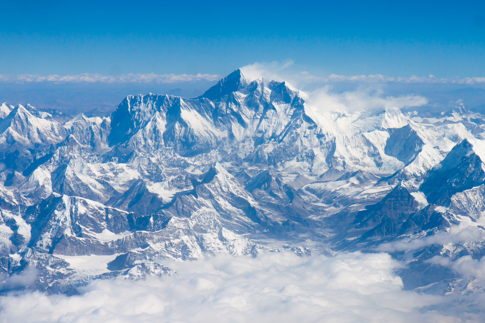
As the world’s highest point above sea level, Mount Everest is one of the most stunning feats of earth many will ever see. Measuring in at 29,035 feet, Everest is the tallest mountain in the world and grows about 4 millimeters every year. The peak is located in the Himalaya mountain range, situated on the borders of Nepal, Tibet and China.
HISTORY
Before a heavy push by the British in 1802 to better map the southern region of Asia, or Indian subcontinent, it was common belief that the Andes were the highest mountain range. This push, known as the Great Trigonometrical Survey, proved to be difficult but highly accurate. By the end of this survey, in 1865, it was determined that Mount Everest measured in at 29,002 feet which modern day GPS proved to be off by a mere 33 feet in 1999.
WHAT CAUSED IT?
It is believed that the Himalaya mountain range began forming around 50 million years ago from the collision of Indian-Australian Plate and Eurasian Plate. The sheer height of Mount Everest attracts thousands of visitors each year, who are willing to shell out thousands of dollars for the opportunity to scale the highest mountain in the world.
FACTS
- In Nepal, the mountain is referred to as Sagarmatha, meaning forehead of the sky, and in Tibet it is known as Chomolangma, meaning mother of the universe.
- On average, it take 12 hours to climb the final mile from the last base camp to the summit.
- The summit of Mount Everest is only slightly below the average cruising altitude of a commercial aircraft.
HARBOR OF RIO DE JANEIRO
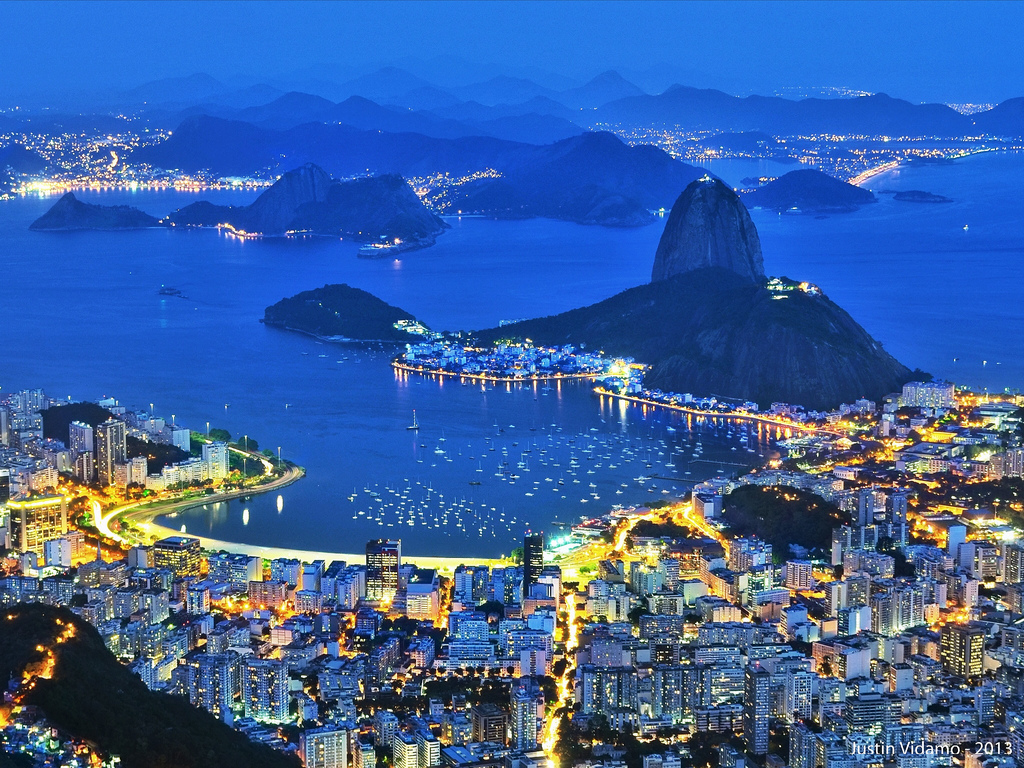
As one of the most beautiful and well recognized harbors in the world, the Harbor of Rio de Janeiro is surrounded by uniquely beautiful mountain formations. Located around the city of Rio de Janiero in Brazil, it is the largest bay in the world based on volume of water alone.
HISTORY
The harbor was first discovered by 16th Century Portuguese explorers who initially thought it was the entrance to a large river and named it for the Portuguese meaning River of January. The bay that serves as the entrance to the harbor, from the Atlantic Ocean, was named by the Tamoio people as Guanabara, meaning arm of the sea.
WHAT CAUSED IT?
The Harbor of Rio de Janeiro was created by erosion of the land surrounding Rio. The harsh process of erosion can still be observed during Rio’s rainy season and allows the bay to be seen as a lake or mouth of a river depending on the specific viewpoint. One of the reasons people are drawn to the Harbor of Rio de Janeiro are the massive granite mountains and islands surrounding the area.
FACTS:
- The entire bay spans the impressive length of 88 miles.
- Within the harbor, there are 130 distinct islands.
- The best view of the harbor is said to be seen from the 1,299 foot Sugarloaf Mountain.
PARICUTIN
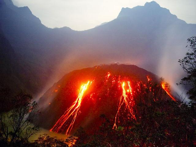
This amazing feat of mother nature is located 200 miles west of Mexico City in the state of Michoacan. It holds the distinctions of being the youngest volcano in the Western Hemisphere, and possibly in the world. This is also the only volcano in history whose entire birth and evolution have been witnessed by humans.
HISTORY
The volcano of Paricutin formed in February of 1943 after residents in the area reported tremors, which were soon followed by a fissure in the ground that began to erupt lava and ash. After only 24 hours, the cone of the volcano had grown to 164 feet and within a week it was close to 500 feet.
WHAT CAUSED IT?
The town in which the volcano is located in is located on an area of roughly 600 miles known as the Trans-Mexican Volcanic Belt. The volcano was able to grow quickly due to eruptions caused by rapidly expanding gas from molten lava. Although the formation of the volcano is common for the type, the emergence of completely new volcanos is extremely rare.
FACTS
- 1 billion tons of lava has emerged from Paricutin in its lifetime.
- The last time this volcano erupted was in 1952.
- The volcano now measures in at 10,400 feet.
If you are looking to appreciate the power and beauty of mother nature, the seven wonders of the natural world are a great place to start. All of these sights are sure to inspire both awe and appreciation in anyone who has the opportunity to visit them.
2 thoughts on “YOUR GUIDE TO THE 7 NATURAL WONDERS OF THE WORLD”